
van der Aa, Pieter
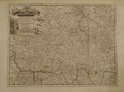
Map. Cercle de Haut Rhin. Suivant les Nouvelles Observations de Mess.rs. de l'Academie Royale des Sciences etc. Augmentees de Nouveau.
back
|
Seller ID: 1310 Leiden, 1729. From Abraham Du Bois, La Geographie Moderne, Naturelle, Historique & Politique dans une Methode Nouvelle.... Sheet (26cm x 40cm), image (22.5 cm x 30cm); decorative title cartouche at upper left with city and river scenes, conjoined cornucopias; ample lateral, good top and bottom margins. The map depicts a portion of the region of the upper Rhine from the confluence of the Rhine and the Main at Mayence (Mainz), west to the Nahe at Rudesheim, and then north to the entrance of the Moselle at Coblentz. The northern watershed of the River Main (Mein) is shown in some detail, as is the watershed of the Weser to the north, formed by the confluence of the Fulda and Werra. Cities and political divisions typical of the region in the 18th century are also shown in some detail. The copperplate engraving is dark and clear. Generally, an attractive mapof Riesling country. Price: $125.00
For more information or to place your order, you can email us at info@trilliumbooks.ca, telephone us at 705-749-0461, |