
Bellin, [Jacques Nicholas]
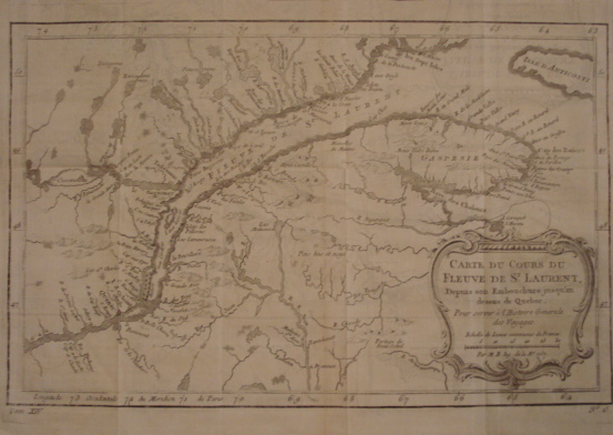
Map. Cartes de Cours de Fleuve de St. Laurent. Depuis son Embouchure jusqu'an dessus de Quebec. Pour servir a la Histoire Generale des Voyages.
back
|
Seller ID: 1302 Paris, 1757. Sheet (33cm x 24cm, irreg.), image (19cm x 30). Engraving depicts the region of the lower St. Lawrence from just west of Quebec City, past Tadoussac, on out to the Gulf as far as the western end of Anticosti Island. Cartouche with legend in rococco frame, a good dark impression locating the settlements and showing details of the tributaries of the lower valley. Likely from Prevost's multi-volume Histoire Generale des Voyages (1746- 1757) for which Bellin prepared maps as Ingr. de la Marine'. Mildly age-toned, a single pin hole on a crease, reduced right margin. Quite a good impression on good 18th century paper with chains and wire, representative of Bellin's accurate, detailed work. Price: $100.00
For more information or to place your order, you can email us at info@trilliumbooks.ca, telephone us at 705-749-0461, |