
[ Jefferys, Thomas].
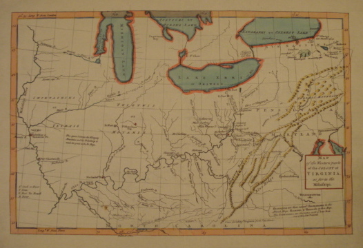
Map. Western Parts of the Colony of Virginia as Far as the Mississipi.
back
|
Seller ID: 1298 London, 1754. Sheet (30cm x 43cm), image (23.5cm x 35.5cm). Late in 1754, subsequent to his defeat at Fort Necessity in the Ohio country by a combined force of French and Canadians, George Washington published at Williamsburg The Journal of Major George Washington which gave an account of his venture into the western lands at the head of elements of the Virginia regiment and which, by implication, served as a defense of his conduct of the campaign (He was, after all, just twenty-one or so and had been captured together with his entire force). A short while later, the Journal was published at London, accompanied by this map by the well-known English cartographer Thomas Jefferys. According to one commentator the 'map is apparently an enlarged version of an earlier map engraved by John Gibson with the same title... published in the London Magazine, June 1754' (See 'Maps Relating to Virginia in the Virginia State Library' in Bulletin of the Virginia State Library 7, Nos. 2 and 3 (1914): 33-263 and mapsofpa.com/18thcentury.) The Jefferys map depicts colonial Virginia as though its north and south boundaries extend west to the Mississippi (and perhaps beyond), a not uncommon notion among the colonial gentry and their surveyors (Connecticut at one time drew similar fanciful and ambitious boundaries), and includes the southern portions of the Great Lakes, the Mississippi (with but one 'p'), and the recently drawn Virginia-Carolina boundary to the south. Locations of French forts along various waterways are noted, and the various connecting tributaries of the Mississippi themselves are presented in some detail (although the eastern tributaries of Mishigan Lake are a bit too evenly spaced). This copy is hand-coloured, probably later-- the lakes are outlined and the mountain ranges high-lighted; what was to become Fort Duquesne and later Fort Pitt and later still Pittsburgh is picked out in red. A short closed tear (repaired) along one wire line is the only fault in an otherwise bright, clear copy of this historically significant map. Ex Ruddell collection (November 2008). Price: $600.00
For more information or to place your order, you can email us at info@trilliumbooks.ca, telephone us at 705-749-0461, |