
Teesdale, Henry
Map. Canada, New Brunswick and Nova Scotia.
back
|
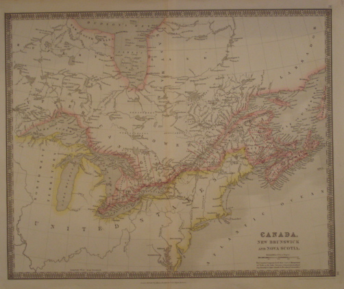
Seller ID: 1296 London, c. 1830. Sheet (37cm x 47cm), image (33cm x 41cm). A fine, colourful engraved map with decorative borders depicting much of present-day Ontario, Quebec, New Brunswick, and Nova Scotia. Showing details of James Bay, the five Great Lakes, the St. Lawrence River and the two maritime provinces, with the northeast U.S. sketched in. Good, wide margins (two small tears, repaired), neat central seam as issued. Date is approximate but close-- Toronto (so named in 1834) is shown as 'York' and Teesdale's major work predates the name change. A bright, colourful map of early 19th century Canada which not much more than a dozen years before had withstood the American invasions of the war of 1812-1814. Ex Ruddell collection (November 2008). Simply mounted on white, acid-free mat. Price: $170.00
For more information or to place your order, you can email us at info@trilliumbooks.ca, telephone us at 705-749-0461, |